Round Trip Distance: 2.0 miles
Trail Rating: Easy to Moderate, well maintained trail. Moderate Elevation Change
Reference: PATC Map 10 (available at entrance stations)
Reference: Heatwole's Guide
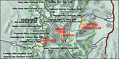
4051 foot Hawksbill Mountain is the highest point in the park. The view is a visual feast if you go on a clear cold day. Follow the trail from the parking area (milepost 47) until it joins a fire road. turn right and continue uphill. You will pass the Byrd's Nest Shelter and come to a walled overlook at the summit. Off to the east you will see Old Rag Mountain. It's distinctive Granite faces are notable from a distance, even more fun to climb on.