Round Trip Distance: 7.0 miles
Trail Rating: For Experienced Hikers Only, Strenuous, partially abandoned trail. Steep Elevation Change
Reference: PATC Map 9 (available at entrance stations)
Reference: Heatwole's Guide
References to Big Devil's Stairs still appear in some older publications, promising a steep canyon full of virgin hemlocks (an exaggeration) and enormous poplar trees (a fact). You are told that the trail can be accessed from route 622 in Rappahannock County. This is no longer possible, since the stretch of trail outside the park on private land has been closed. The canyon scramble many of us remember has been abandoned.
There is a "Big Devil's Stairs Trail" that skirts the canyon and gives you a nice view of the canyon from one outcropping. If you want to see the canyon "up close and personal" you will have to follow unmarked trail and be very experienced. Several years ago a friend and I went to see this wonderland and we realized as we descended the new trail that it had no intention of going into the canyon. We returned another day to try to find our way down the old trail. We did find it and here we describe the journey.
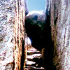
At Gravel Spring Gap ( milepost 17.5) Go to the Gravel Spring Hut and turn east on the Bluff Trail. There is a marked "Big Devil's Stairs Trail" that heads south from this trail. follow this trail to a rocky outcropping that allows you to view the canyon and continue on down to the bottom. Where the trail crosses the creek you may be able to pick up traces of the old canyon trail. You'd better be good at reading trail, and go in the winter. The fun begins pretty soon as the old trail literally goes into the creek. You'll probably get a bit confused and have some fun working your way up over the rocks. This is a rough, rocky canyon with steep walls in places. Give yourself all day for this adventure.
You'll probably see some big poplars, but alas, the hemlocks of my friend's memory are in sorry shape [mostly gone as of 2006] thanks to the Hemlock Wooly Adelgid (Adeleges Tsugae) infestation and you will mostly see the fallen trunks of the older trees. You really won't see much hemlock at all until you are coming out of the top of the canyon. No doubt, this trail will put you to work. I can still close my eyes and see visions of my companion sliding down the rocks at one particularly tight spot. Traces of the old trail exist and even a few tree blazes, but you've never climbed over so much rock and dead wood in your life! When all else fails, follow the creek.
All good things must come to an end, and you will eventually reach the Bluff Trail. Turn left and follow it out to Gravel Springs Gap and your car.