1. Mary’s Rock Trail
Round Trip Distance: 3.8 Miles from Panorama
Trail Rating: Moderate/Difficult in places.
Over 1000 foot elevation change.
Reference: PATC Map 10 (available at entrance stations).
Reference: Heatwole's Guide
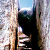
At Thornton Gap (between milepost 31 and 32) go to the short trail behind the Panorama Restaurant and follow it to the Appalachian Trail (white blazed). Turn left on the AT and follow it as it ascends to the rock. After about 1.2 miles the Appalachian Trail will make a sharp left turn and the trail to the rock will continue straight ahead. The view in all directions from the 3514 foot summit (slightly beyond the overlook) is worth the trip.
2. Mary’s Rock via Meadow Springs Trail
Round Trip Distance: 2.9 Miles
Trail Rating: Easy/Moderate Difficulty
About 800 foot elevation change.
Reference: PATC Map 10 (available at entrance stations).
Another hike to Mary’s Rock may be made from the Meadow Spring Trail (between milepost 33 and 34). Take the Meadow Spring Trail (blue blazed) to the Appalachian Trail and turn right. Follow the white blazed A.T. until the trail to the rock turns off to the left. This way is not as rugged a hike as the walk from Panorama.
3. Hazel River Falls and Cave
Round Trip Distance: 5.4 Miles From Meadow Springs Trail Parking.
Trail Rating: Moderate Difficulty, Steep in a few places. Some unmarked trail (experienced hikers only).
About 1000 foot elevation change, uphill return.
Reference: PATC Map 10 (available at entrance stations).
From the Meadow Springs Trail parking area (between milepost 33 and 34) cross the Skyline Drive and follow the yellow blazed Hazel Mountain Trail past the Buck Ridge Trail and bear left on the White Rocks Trail (also yellow blazed). Follow White Rocks Trail .8 miles to a narrow, unmarked footpath that descends steeply to the Hazel River. If you walk to the right at the bottom of this path you will see the falls. In the cliff to the right is a rock overhang that creates a natural shelter and at one end of the shelter you will find the cave. It is not a big cave and you will have no need of a carbide lamp as the daylight is quite adequate for you to explore it.
Carefully retrace the unmarked path left and up the hill to the White Rocks Trail. Turn left and follow it to the Hazel Mountain Trail where you will bear right to return to Skyline Drive.